Month: December 2022

True Orthophoto in Engineering & Earthworks Explained

When drones capture images or video, the data can be used in a number of ways. Looking at the raw footage can offer valuable insights, but using photogrammetry to create true orthophotos, 2D orthomosaics, and 3D models allows you to take measurements, track changes, and much more. Using a true orthophoto is one of the ways engineers are able to get accurate data about site conditions, allowing them to make informed decisions without having to visit a site.

What is a true orthophoto?

The first step in understanding the difference between an orthophoto and a true orthophoto is understanding how the digital terrain model (DTM) differs from the digital surface model (DSM). The DTM, which is used to create an orthophoto, prioritizes the accuracy of the natural terrain and excludes manmade structures and vegetation. The DSM, which is used to create a true orthophoto, prioritizes accuracy in mapping every physical object that is present. In an orthophoto, buildings and other structures will appear tilted, but in a true orthophoto, photogrammetry software has corrected for these objects to provide an accurate vertical view. 

Before drone photogrammetry existed, getting a true orthophoto was very expensive because it required a combination of ground measurements and light detection and ranging (LiDAR) images captured from an aircraft. Drone photogrammetry can now create an orthomosaic, which is a series of images stitched together, to create the same effect as a true orthoimage. It does this by using 3D point cloud data to create an accurate digital surface model.  

How are orthophotos used in engineering and earthworks?

Engineers use drones and photogrammetry to support earthworks projects in a number of ways:

Validate existing conditions.

Confirm that the site has not changed since the initial survey before starting work.

Estimate demolition quantities.

Plan with accuracy to determine the amount of materials, vegetation, or concrete that needs to be removed from a site.

Improve site organization.

Use orthoimages to identify the best areas to store materials, set up transfer areas, and plan routes.

Monitor progress. 

Compare maps over time to see how quickly the project is progressing, including measurements of the amount of earth moved.

Perform jobsite inspections.

Remotely assess actual work completed compared to plans, determine how much material must be procured, and validate site organization.

Capture as-builts. 

Provide accurate maps to the project owners and the next contractors who will be working on the project.

screenshot of construction drone orthophoto in Mapware

What are the benefits of using orthophotos?

Although it’s possible to gather information through site visits and other means, using orthophotos has advantages over other approaches.

They allow for remote access.

Save time and resources by gathering data remotely. Drones allow for quick data gathering and analysis with fewer people on-site. When you use a drone, there is no need for expensive flights or heavy equipment rental. They are also great for getting data on remote or difficult-to-access sites.

They improve safety.

Safely measure inventories and stockpile quantities without having to walk the site. You can also remotely monitor the jobsite for safety hazards. Proactively identify pathways that are blocked and items that need to be moved before they become problematic. 

They make collaboration and documentation easier.

Digital tools make it easy to collaborate with team members and store images for future needs. Quickly share data with all key stakeholders with cloud-based maps and software so you can streamline communication, even for those who are not on-site. You can also integrate true orthoimages and orthomosaics with other software to validate drawings, monitor progress, and overlay plans. Throughout the project and upon completion, document the site to protect against future claims.

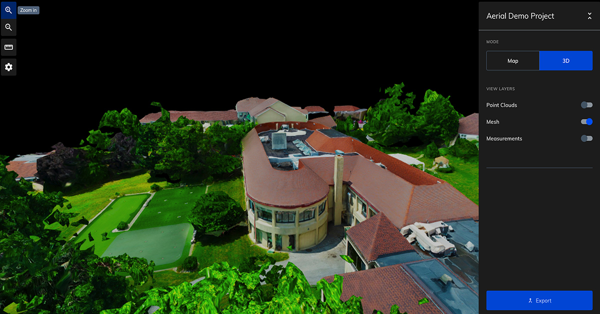
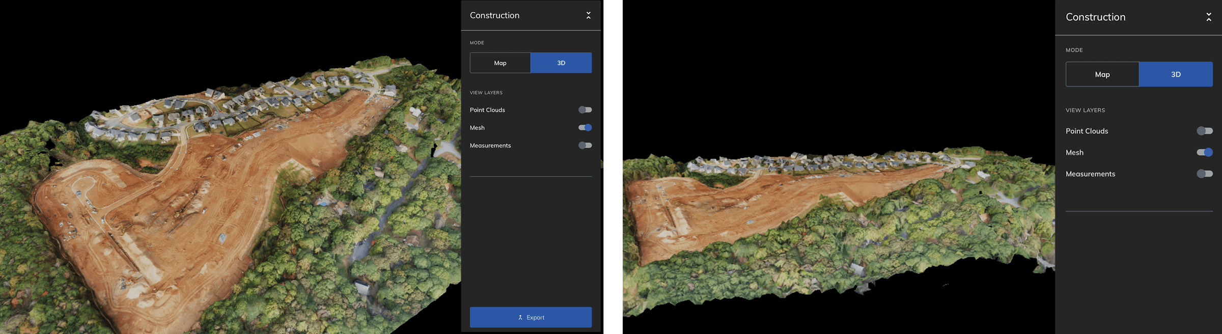
Generate true orthophotos with Mapware.

Mapware photogrammetry software makes it easy to generate orthophotos and orthomosaics for your engineering projects. The best way to experience how drone mapping can improve your work is by trying it for yourself. Give Mapware a test-drive to see how quickly you can measure materials, monitor jobsites, and more. 


Ready to put Mapware to work for you? Start a free trial today!

learn how the public sector drives innovation with geospatial intelligence and data driven mapping ebook

Santa’s Little Helper: Why Santa Needs 3D Mapping and Geospatial Intelligence

Santa’s been making his rounds for a long time, and you’d think he would have perfected his delivery method by now. But as the world’s population continues to grow, and more children are added to the “nice” list each year, it becomes increasingly difficult for Santa to make his deliveries on time. That’s where 3D mapping, and geospatial intelligence come in!

With these tools, Santa can optimize his Christmas Eve operations and plan his route more effectively. Read on to learn more about how Santa can use 3D mapping and geospatial intelligence to make his midnight ride as efficient as possible.

The challenges of Santa’s current operations

Santa has a lot on his plate during the holiday season. He must make sure all the gifts get delivered on time (to an ever-increasing number of good boys and girls), keep track of who’s been naughty and nice, and sneak into homes without being seen. It’s a daunting task, and Santa could use a little help.

Among other reasons, Santa’s current operation is inefficient because he relies on sleighs and reindeer to deliver presents to children around the world – leading to increased costs and a tight timeline. Without the ability to accurately map out routes, Santa relies on outdated methods of navigation, which result in inefficient courses and longer delivery times. Not to mention, the always evolving world map. Every year, new roads and buildings are built, which can throw off even the most experienced navigator. 

Additionally, safety concerns often arise when Santa is not able to accurately map out routes ahead of time. Without the ability to accurately identify obstacles and other potential hazards, Santa is at risk of getting lost or running into danger. Under his current operations, he is limited in the ability to collaborate with other delivery services, which leads to inaccurate data and unreliable delivery times. While this method may have worked in the past, it is no longer efficient in today’s world.

With current technology, there are much more efficient ways for Santa to deliver presents to children that don’t present serious consequences for the efficiency and safety of his delivery operations.

What is geospatial intelligence and 3D mapping?

Santa has been using the same map for centuries. It’s time for a change. With the help of 3D mapping and geospatial intelligence, Santa can deliver presents to all the good boys and girls without fail.

What is geospatial intelligence? Simply put, it informs confident decisions and better business outcomes by leveraging location to add context to data. With the help of geospatial intelligence and maps, Santa can see exactly where each child lives, what they want for Christmas, and whether they’ve been naughty or nice.

3D mapping is also a great way to show changes over time. For example, if you wanted to see how a city has changed over the years, you could create a 3D map of that city and track continuous alterations…like adding chimneys. This is something that Santa could use in his workshop!

Additional benefits Santa can experience with GIS and photogrammetry

With Christmas just around the corner, Santa is no doubt busy making his list and checking it twice. But what if Santa could use some help to make his midnight ride more effective?

With photogrammetry, Santa can optimize his ride by viewing the most direct routes to each house on his list. Not to mention how he could track his sleigh’s position in real-time, create a 3D map of each house he visits, and even see what the inside of each house looks like. With all this data at his fingertips, Santa would be able to make his deliveries with pinpoint accuracy.

By using these tools, Santa can be sure that he is making the most efficient use of his time and resources. This will not only help him fulfill his duties on Christmas Eve, but it will also ensure that every child gets their fair share of holiday cheer.

Best practices for processing and analyzing geospatial data

Image by Freepik

Let’s face it, Santa has a lot of data to manage. Billions of children’s Christmas lists, global weather patterns, Rudolph’s nose-tracking data – the list goes on. And with all this data comes the challenge of processing and analyzing it quickly and efficiently.

But don’t worry, Santa – help is on the way in the form of 3D mapping and geospatial intelligence. By using these tools, Santa can manage his data more effectively and make better decisions about where to deliver presents on Christmas Eve.

Not only will this make Santa’s job easier, it will also make sure that every child receives their Christmas present on time.

Mapware makes Santa’s merrymaking easy with maps

Image by Freepik

So, if you’re looking for a way to help Santa make his Christmas Eve delivery run as smooth as possible, consider recommending Mapware and the benefits of 3D mapping and geospatial intelligence. It’s sure to make everyone’s holiday season a little brighter.

The best way to see if 3D mapping with Mapware is right for you or old saint Nick is to test-drive it yourself. Start a free trial today!

UAV Mapping & the Benefits of Drone Technology

Technology has changed the ways we do almost everything. In the past century, drones—  also known as unmanned aerial vehicles (UAVs)—have evolved from radio-controlled devices used primarily for military purposes into widely accessible tools used by governments, organizations, and individuals for research, monitoring, recreation, construction monitoring, and more.

One particular function, UAV mapping, has a broad range of applications that are improving outcomes in a variety of industries.

What Is UAV Mapping?

UAV mapping is the use of drones with cameras and photogrammetry software to provide accurate geospatial intelligence about an area. Images are collected and then stitched together to provide maplike 2D orthomosaics and 3D models. Because the maps use photos, users can get near-real-time information about the area. The data can be integrated with other software, maps, and images, for tasks such as:

  • Taking measurements
  • Detecting change
  • Identifying anomalies
  • Calculating distances 

Whether used in the public sector or by private companies, UAV mapping is changing the way we do business. 

UAV Mapping in the Real World

UAV mapping has been used for a broad range of applications, and more use cases are being tested every day. Examples of Mapware UAV mapping in action include:

  • Emergency management after a natural disaster to assess and prioritize damage to buildings and infrastructure
  • Virtual reality for mission planning and safety hazard identification after disasters such as wildfires and floods
  • Infrastructure damage assessment to improve safety and response time for disaster recovery efforts

Whether being used by utility companies, private enterprises, or regional governments, UAV mapping delivers real-world results that help protect employees and citizens alike. 

Benefits of Drone Technology

Mapping has historically been done with satellites, planes, and on-site techniques that require specialized equipment. With drone technology and photogrammetry software, mapping can be achieved much faster, cheaper, with more accuracy, and with more flexibility and safety.

Speed 

Unlike planes and satellites, drones can be deployed in a specific area any time. They can be preprogrammed with flight patterns to improve efficiency and ensure consistency, and they don’t require you to wait for satellite locations to align with your site.

Cost

Drones require smaller teams—and, therefore, smaller budgets—to deploy. Sometimes just one person can execute the mission, and there is no need to send people into the field with specialized equipment. UAV mapping also eliminates the costs related to flying planes and purchasing satellite imagery.

Accuracy

Photogrammetry software automatically corrects for perspective, camera angle, distance, and other factors to provide accurate 2D and 3D maps. What used to require specialized expertise and days or weeks can now be done with better accuracy in a matter of hours. 

Flexibility

Drones can fly below cloud cover, between buildings, under trees, and even inside active construction sites to gather information. They can also be used when planes and satellites are not available, or if there is limited visibility.

Safety

Unmanned aircraft present fewer risks than flying planes. Field inspections can also be performed remotely and around construction sites from various heights, reducing risk to individuals.

Mapware Makes UAV Mapping Easy

Whether you need the security of a U.S.-based software company, an easy user interface, or the ability to process massive amounts of data, Mapware offers all of this and more. Our cloud-based platform makes it easy for you to quickly capture, process, and share map data with the people who need it most. We work with professionals across a range of industries, including government agencies, to help teams work faster, smarter, and more efficiently.  

The best way to see if UAV mapping with Mapware is right for you is to test-drive it yourself. Start a free trial today!