Mapware Listed as a Leader in Photogrammetry on the #1 Independent Software Review Site – G2

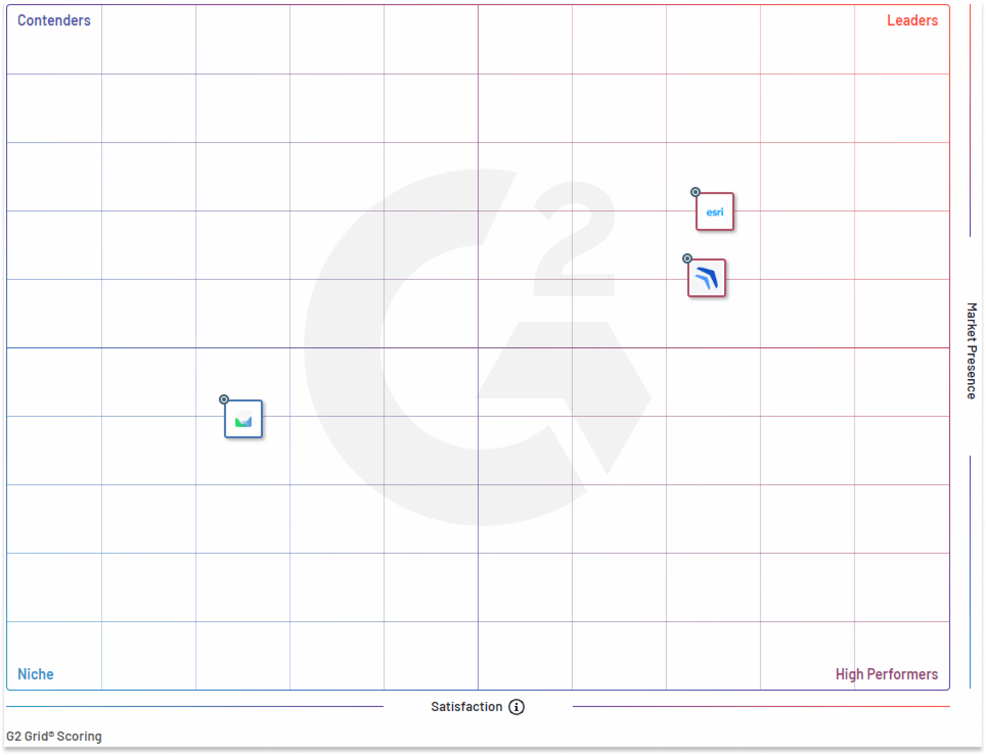
Mapware is proud to be listed as a leader in Photogrammetry on G2. We are one of the three Photogrammetry solutions (out of 40 total listings) included in G2’s Grid that have been recognized by G2’s unique methodology, which evaluates thousands of programs based on specific criteria such as ease-of-use, customer support, and user satisfaction.

Our customers have spoken

This is an exciting achievement, as we continue to work hard to develop a tool that serves the incredible photogrammetrists and Geospatial Intelligence professionals of the world and helps make their jobs easier.

Customers on G2 have recognized Mapware for its speed, ease of use and support. They also reinforce our dedication to build a tool that serves our customer’s needs and helps make the global mapping experience more enjoyable and effective.

We’re excited about this recognition from G2, but even more so because it means we get to keep doing what we love – helping people create innovative 3D maps!

Mapware reviews sourced by G2

Of the thousands of products evaluated using G2’s unique methodology, only the top-performing products are recognized in a quadrant

Mapware is one of two photogrammetry solutions to be listed as a leader by G2 (right alongside Esri), the world’s largest independent software review site. This recognition is based on our innovative photogrammetry tools, user experience and data from real users who have rated five stars.

To evaluate which products, deserve this designation G2 reports “G2 scores products and sellers based on reviews gathered from our user community, as well as data aggregated from online sources and social networks. Together, these scores are mapped on our proprietary G2 Grid®, which you can use to compare products, streamline the buying process, and quickly identify the best products based on the experiences of your peers.”

We are appreciative to all the photogrammetrists and 3D mapping professionals who used and reviewed Mapware and are excited to keep improving our tool to ensure customers keep having outstanding experiences.

Conclusion

We are proud to be a leader in the Photogrammetry quadrant and look forward to this path of innovation as we continue to develop and release new features that will make your photogrammetry and data collection process easier than ever before! Have some thoughts about your experience with Mapware that you’d like to share? Submit a review here!

Introducing Mapware Fly for DJI Drones: Automated Flight Planning, Flight Control & Capture for Accurate, Detailed 3D Mapping

New, free Android app lets anyone reliably capture landscapes and points of interest for high‑quality drone photogrammetry

WASHINGTON–(PRWEB)–Mapware, Inc. (mapware.com) has announced the immediate availability of Mapware Fly — a new, radically simple app for automated drone flight planning, flight control, and image capture for high-quality photogrammetry (3D mapping).

The Mapware Fly app debuts with support for Android tablets and the DJI Mavic 2 Pro, DJI Phantom 4 Pro V2.0, DJI Mavic Air 2, and DJI Mini 2, and is available now on the Google Play app store. Anyone interested in support for additional drone models and iOS can opt-in to receive Mapware news at https://mapware.com/contact-us/.

“As the first free, automated photogrammetry flight app to support the DJI Mini 2, Mapware Fly will bring the magic of 3D mapping to more people than ever before,” said Mapware CEO Joe Sullivan. “Additionally, our support for DJI’s Mavic 2 Pro, Phantom 4 Pro V2.0, Mavic Air 2, and DJI Mini 2 is just the start of what will soon be deep integration for all popular UAVs used by professionals. Mapware Fly demonstrates how serious we are about our mission to offer the power of Mapware’s geospatial intelligence platform to everyone, from one-person teams to our largest customers.”

Features & Benefits:

  • Direct Upload to Mapware — As missions are completed, users can sync the captured images with their Mapware account to turn captured images into accurate, detailed 3D maps and orthomosaics.
  • Terrain Following — Mapware Fly users can set a target altitude for their automated flight. When terrain following is turned on, the drone’s height above ground level will automatically adjust as the underlying terrain changes.
  • Automated Flight Path Creation — Users simply draw an outline of their “area of interest” on an interactive map, and Mapware Fly will automatically create the optimal flight path based on their configured flight parameters.
  • Preflight Checklist — Mapware Fly helps users perform successful missions with a preflight checklist at the start of each flight. The app confirms that the drone is properly connected, has enough battery life to perform the mission, and that the flight path doesn’t encroach on restricted airspace.
  • Automated Flight Control and Capture — Once the flight path is defined and the preflight checklist is acknowledged, Mapware Fly automatically executes the capture – eliminating the potential for human error inherent in manual captures.
  • Live Video Preview — Users can see a picture-in-picture drone’s-eye-view to confirm that the drone is working correctly, and the mission is going as planned.
  • Live Telemetry — During flights, users can view real-time drone telemetry information including Above Ground Level (AGL) altitude, Mean Sea Level (MSL) altitude, horizontal and vertical speed, SD card space remaining, drone battery, and distance to home (takeoff location).
  • Offline Operation — Users can plan and execute drone missions at a remote site without needing a Wi-Fi or cellular signal.
  • View Restricted Airspace — While planning a flight, Mapware Fly automatically highlights “restricted” and “authorization” airspace zones on the mission map. With this feature, users can feel confident that their drone flights are compliant with local restrictions.
  • Project Organization — Missions can be organized into projects, which is helpful for managing multi-mission projects, organizing missions by customers, and more.
  • Create Missions Without a Connected Drone — Users can create and plan a mission without connecting their device to a drone. This feature allows users to plan missions before they go out into the field, so they don’t waste valuable field time.
  • Cloud-Based Projects — Project and mission data is synced to users’ Mapware accounts. This synchronization allows the user to create a complete or partial mission on one device, log out, and then log in on another device to continue mission planning and execution.

Device Support

Mapware Fly supports Android tablets running Android 11 and newer, and the DJI Mavic 2 Pro, DJI Phantom 4 Pro V2.0, DJI Mavic Air 2, and DJI Mini 2. Support for additional devices is coming soon. Anyone interested in support for additional drone models and iOS can opt-in to receive Mapware news updates at https://mapware.com/contact-us/.

Customers can view additional details and download Mapware Fly for Android at https://mapware.com/fly/.

About Mapware, Inc.

Mapware is a U.S.-based SaaS platform designed to make advanced geospatial intelligence available to everyone. With Mapware, anyone can turn drone photographs into rich, immersive 3D and 2D virtual environments. Mapware makes it easy to explore, understand, and share these detailed “digital twins” of the physical world. It combines advanced algorithms with a simple, easy-to-use interface to provide an intuitive and powerful photogrammetry system.

Mapware’s GPU-accelerated cloud processing platform makes it an ideal solution for time-critical, resource-intensive projects. Mapware’s extensible geospatial intelligence capabilities enable users to better understand the world around them and act decisively within it.

Mapware’s latest product, Mapware Fly, is an Android app for automated flight planning, control, and image capture. When used with the Mapware web app, Mapware Fly makes it easy to create accurate, detailed 3D and 2D maps.

Contact

Mapware
Warren Tessier
press@mapware.com
215.550.1823

Mapware Awarded Strategic Expansion with U.S. Air Force

As of April 2021, Aerial Applications is now Mapware. The title of this archived release has been changed to reflect the new business name.

WASHINGTON–(BUSINESS WIRE)–Aerial Applications (mapware.com), a software company specializing in GPU-accelerated data processing of drone imagery to make maps, was today awarded the US Air Force Small Business Innovation Research (SBIR) Phase II B Strategic Fund Increase Pilot Program.

“Aerial Applications has been a fantastic and talented partner and are well positioned to deliver this advanced drone imagery and machine learning capability for multiple installation and mission support enterprise uses. We look forward as this innovative partnership grows over the next four years”
Tweet this

The program brings together commitment from both the public and private sectors to help advance the U.S. National Strategic Science and Technology goals through strategic funding. The program includes continued product development and integration over a 4-year period.

The announcement was made during the Virtual Spark Collider, Pitch Bowl, and STRATFI Showcase, in lieu of South by Southwest in Austin, Texas, by Dr. Will Roper, Assistant Secretary of the Air Force for Acquisition, Technology and Logistics. Known as a center of rapidly growing technology and innovation, Austin has been expanding its footprint with the Department of Defense as the new home of the Army Futures Command and is one of the three Air Force AFWERX Innovation Hubs along with Washington D.C. and Las Vegas.

The program gives Aerial Applications 4 years and $6 Million of R&D funding to help advance the development of environmental monitoring bolstered by artificial intelligence to support an Air Force Installation and Mission Support Center innovation initiative. Their initial project, mapping the habitat of the endangered golden-cheeked warbler at Camp Bullis in San Antonio, Texas, will be expanded significantly to include other species and applied to 20+ different use cases in at least 12 locations.

Using unmanned aerial vehicles, teams can rapidly create environmental maps that help achieve compliance with Department of Interior requirements. This transition from a manual inventory process to an automated one, will save an estimated $8-16 million per year for the Department of Defense.

“Aerial Applications has been a fantastic and talented partner and are well positioned to deliver this advanced drone imagery and machine learning capability for multiple installation and mission support enterprise uses. We look forward as this innovative partnership grows over the next four years,” said Marc Vandeveer, AFIMSC chief innovation officer.

The Pilot Program also emphasized the need for Dual-Use solutions – meaning technology that would be used by customers beyond the Federal Government. Aerial Applications has been working with telecommunications organizations to create, test and refine 5G solutions for public safety. One such solution will leverage drone technology to monitor and prevent wildfires.

The selection process has involved a 3 round down select, beginning with hundreds of highly promising technology startups. Aerial Applications was honored to win the award over hundreds of highly promising technology startups.

In this Air Force Small Business Innovation Research Phase 2 partnership, Aerial Applications expects to develop advanced artificial intelligence and mapping analysis tools. This will be widely applied to multiple different use cases across the DoD to help improve environmental protection and compliance.

This award follows a number of recent achievements and partnerships for Aerial Applications. Last year, the D.C.-based software company closed a $4.5 million equity funding round just months after being named as part of the first cohort of companies.

“We’re excited and humbled to have earned this amazing opportunity to develop, deploy and scale our technologies. From wildfires to polar bears, we’re proud to support Air Force missions in diverse environments and applications,” said Aerial Applications CEO Joe Sullivan. “Our team can’t wait to prove how drones and AI can save lives, help humanity tackle complex problems at scale, and make advanced geospatial intelligence accessible to everyone.”

About Aerial Applications

Aerial Applications provides web-based data management, processing, and Al image analysis software as a service (SaaS) for drone-enabled enterprises, using advanced acquisition and geospatial techniques to collect and refine big data. Our multi-stage proprietary system combines advanced algorithms with a simple, easy-to-use interface to provide an intuitive, powerful photogrammetry engine.

Our cutting-edge technology and reliable, always-on data processing system means we can easily tackle time-critical, resource-intensive projects. We leverage drone, Al, and automation technologies to revolutionize infrastructure and environmental management and create a safer, more insightful, more meaningful work experience for humans.

About AFWERX

Established in 2017 by the Secretary of the Air Force and reporting to the Vice Chief of Staff of the Air Force, AFWERX is a catalyst for agile Air Force engagement across industry, academia and non-traditional contributors to create transformative opportunities and foster an Air Force culture of innovation. The ultimate aim is to solve problems and enhance the effectiveness of the Air Force.

About USAF IMSC

The Air Force Installation and Mission Support Center serves as the single intermediate-level headquarters staff supporting AF-wide installation and expeditionary support activities. AFIMSC’s mission is to deliver globally integrated installation and mission support to enhance warfighter readiness and lethality for America’s Air and Space Forces.

Contacts

Aerial Applications
Jeff Brooks, CMO
press@mapware.com
(512) 364-3109