Month: April 2022

Five Reasons to Beta Test Mapware Fly Right Now

We’re building a brand-new automatic flight control, navigation, and image capture app for drone photogrammetry and we’re looking for pilots to beta test it. Here are five reasons you need to sign up literally right this minute.

Introduction

Hold on, let me get this straight… you need reasons to take your drone to the park on Sunday and use cutting-edge flight control software to generate 3D digital twins that you can then email to your friends, all while bragging that you are helping usher in the metaverse?

No problem! Below are five good reasons to sign up as a Mapware Fly beta tester.

(Then again, if you can’t wait to get started, click this link to sign up now: https://bit.ly/3EdtN0R.)

1) Free Photogrammetry for 3 Months

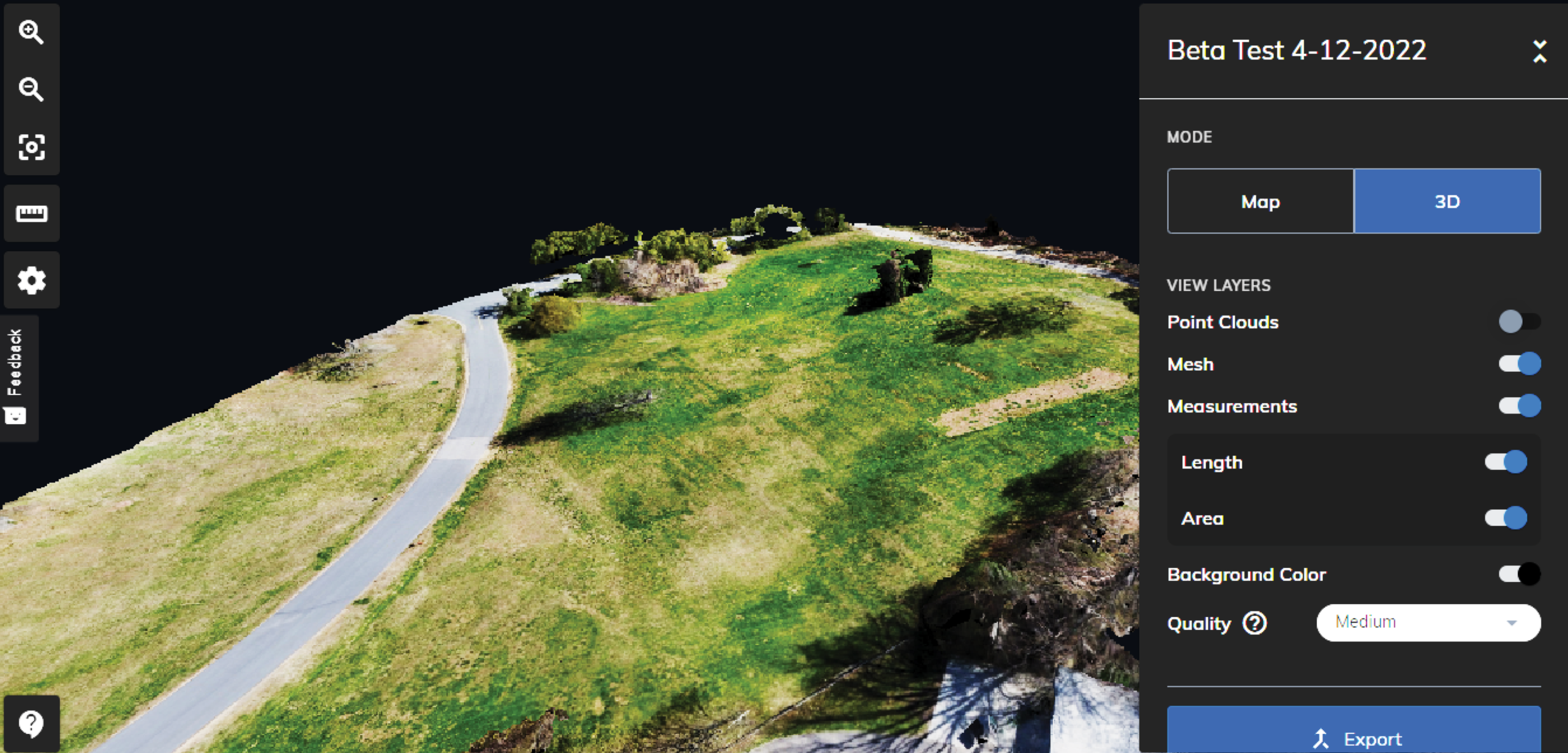
As a beta tester, you’ll get to use our cloud-based photogrammetry platform for free for three months. This is the equivalent of a three-month subscription to our Mapware Solo Plan, which would normally cost $417.

This means you can turn all the drone photos you collect during the beta test into 3D “digital twins” of physical spaces — a lot like the realistic environments in Microsoft Flight Simulator but representing whatever site you fly over.

While your Solo plan is active, there’s no limit to the number of times you can download these digital twins from Mapware. You’ll have plenty of chances to impress your friends.

A 3D digital twin generated during a beta test of Mapware Fly using a DJI Mini 2 drone
Can you generate a better digital twin than the author of this blog post? (Yes.)

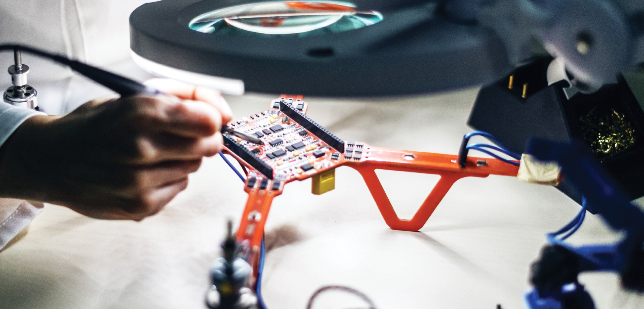
2) Feel Like a Test Pilot

Unless you have an engineering degree and thousands of flight hours, you probably don’t often get to fly drones equipped with experimental software. This is your chance to break out those Ray-Ban sunglasses and add a little swagger to your step.

In all seriousness, the more intelligent eyes we have on Mapware Fly, the more we can perfect it to serve real-world drone mappers. If you’re a responsible pilot, an analytical and systematic thinker, and opinionated about your toolset, we’d love to have you onboard.

A test pilot straps on his helmet while sitting in an airplane labeled "Mapware Flyer".
You, headed out to the field with your quadcopter.

3) Help Us Build the Tool You’ve Always Wanted

Unless you’re new to drone mapping, you’ve probably already used similar apps for photogrammetry image capture. If you’ve ever been dissatisfied by complex menus and submenus, unhelpful telemetry readouts, or inadequate features, this is your chance to help us build a flight app you’ll actually enjoy using in the field.

Early testers have told us Mapware Fly is intuitive and simple. But it can get even better with your help. In fact, you can help us steer our design, not just refine it. Perhaps you’ll propose a new feature we (and other app designers) haven’t thought of yet.

A drone airframe sits open on a table while a technician solders its motherboard.
Beta testing gives you a direct line to our development team.

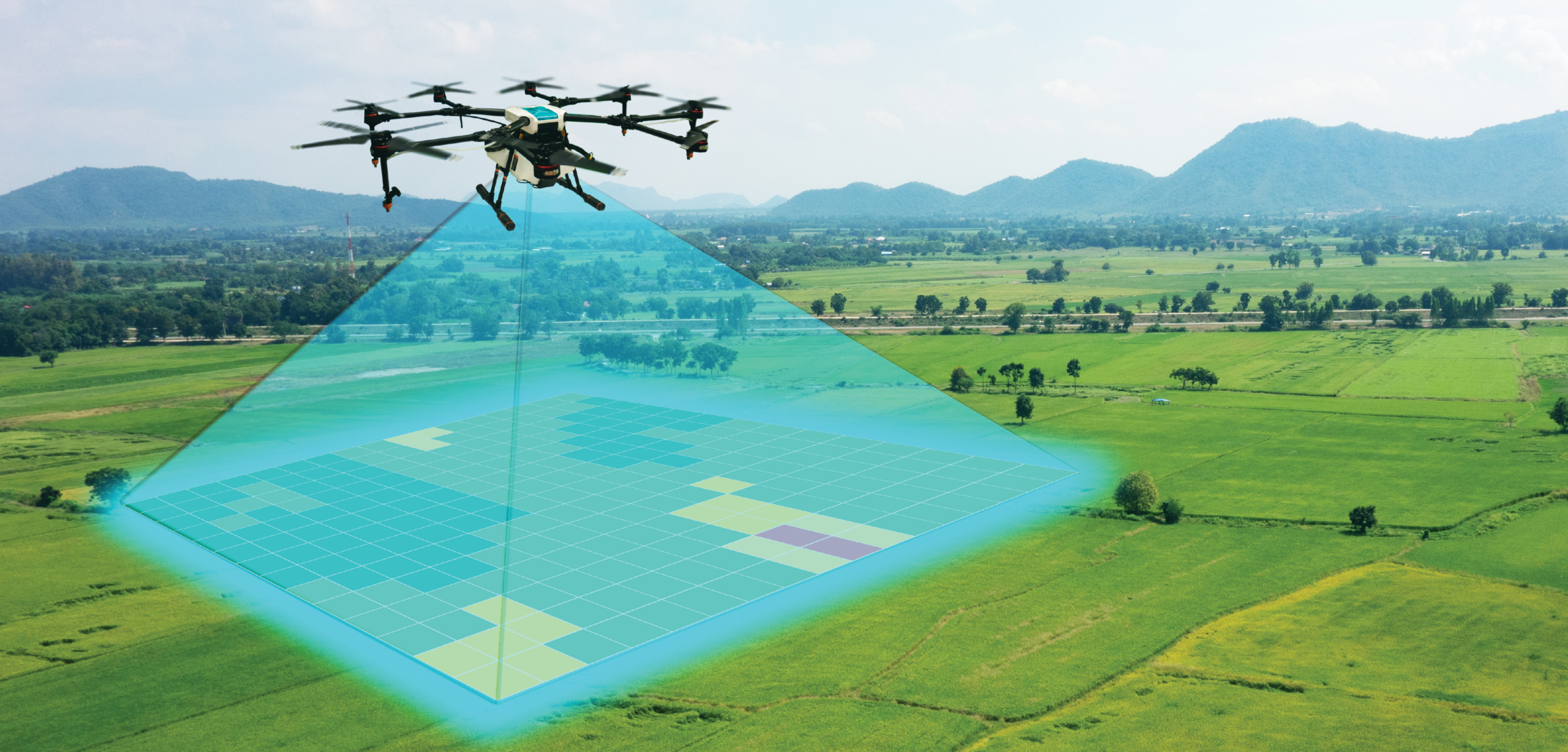
4) Explore the Drone Mapping Career

With the “metaverse” concept becoming commonplace and the growing interest in recreating practically everything as a digital twin (from single-family homes to entire cities like Dubai), drone photogrammetry will become a major income stream for pilots.

If you’re a newly minted Part 107 pilot looking for your first business idea, photogrammetry may seem too exotic and out of reach. Most people don’t even know what the word means. By signing up as a beta tester, you can try drone mapping out with minimal risk. Mapware Fly walks you through the flight planning process and does all the image capture work for you. Who knows — maybe it will inspire you to go pro.

A drone flies over a landscape mapping a square section of grass.
Drone mapping is a great niche for tech-savvy pilots, and we make it easy to start.

5) You Have a Mavic 2 Pro, Phantom 4 Pro V2.0, Mini 2, or Mavic Air 2

If you sign up with a DJI Mavic 2 Pro or DJI Phantom 4 Pro V2.0, you can test Mapware Fly right away. These are the first airframes we made compatible, and they will offer you the full experience.

If you sign up with a DJI Mini 2 or DJI Mavic Air 2, you won’t have to wait long. We’re finalizing compatibility with those drones right now and we’ll notify our beta testers as soon as we feel the app is ready. FYI, we expect Mapware Fly to be the first free photogrammetry flight app to work with the DJI Mini 2.

If you don’t have any of the above drones, we’d still love to hear from you. Your survey response will help us prioritize which airframes to support next.

A composite image showing (clockwise starting from the top left corner) a DJI Phantom 4 Pro V2.0, DJI Mini 2, DJI Mavic 2 Pro, and DJI Mavic Air 2.
Any of these beauties look familiar? This is just the starting lineup.
(DJI – Drohne Mavic Air 2.JPG” by Bwag, used under CC BY-SA 4.0 / desaturated from original)

I mean, really, this isn’t tax preparation software we’re talking about. It’s flying drones and creating 3D models. Those of us who get to go out to the park and beta test Mapware Fly have had a blast in the process. And tech like this has so many useful applications, many of which haven’t even been identified yet.

Click this link to sign on as a beta tester. Have fun: https://bit.ly/3EdtN0R

What is Terrain Following?

Terrain following is an important feature for drone flight planning software, but not all apps on the market support it. Pilots should understand how it works to maintain regulatory compliance and capture high-quality image sets.

Introduction

Flight planning, automation, and image capture apps are essential tools for professional drone mappers. They save time and battery life, reduce pilot workloads, and enhance image quality. But many options on the market are designed to automate flights over flat terrain. To map areas with changing elevations, you need more granular altitude control than that provided by most waypoint flight plans. This is why some flight app designers have added an advanced feature called terrain following.

This article describes the purpose, benefits, and limitations of terrain following so you can decide if it’s worth having.

The problem with lawnmower flight patterns

Most flight apps create what are sometimes called “lawnmower” flight patterns. The name comes from the way they sweep a drone back and forth over the landscape at a fixed altitude. Lawnmower patterns ensure full horizontal coverage of the site but make few (or perhaps no) changes to the drone’s altitude. Instead, these apps let the pilot set a fixed mission altitude beforehand. When the mission starts, the drone climbs to that altitude and stays there until the mission is complete.

Fixed altitude is fine if you are mapping a parking lot in Florida. With no significant elevation changes, your drone camera stays roughly the same distance from the ground when it snaps each photograph. But what if you are mapping a hiking trail in West Virginia? The terrain will rise toward the drone and fall away from the drone, perhaps drastically. This causes the drone’s real-world height above the ground to fluctuate, negatively impacting your mission in several ways.

In the extreme case, your drone might risk crashing into the terrain or breaching FAA altitude limits. More likely, though, changing elevations can introduce subtle variations in your image set that result in a poor-quality 3D model. More on this later.

A drone without terrain following flies at a fixed altitude over mountainous terrain, placing it at varying heights above ground level (AGL).
Without terrain following, an automated image capture flight plan carries a drone in a straight path over uneven terrain, placing it at varying heights above the ground.

The purpose of terrain following

With terrain following, a flight app makes real-time adjustments to your drone’s altitude to mirror the contours of the terrain. Instead of flying straight, the drone climbs and descends in real-time to maintain its ideal height above the ground throughout the mission. In aviation terms, terrain following helps your drone maintain a consistent altitude above ground level (AGL).

A drone with terrain following flies over mountainous terrain, maintaining a consistent height above ground level (AGL) despite elevation changes.
With terrain following enabled, an automated image capture flight plan varies the drone’s altitude to maintain a consistent height above the ground.

How does it work?

Flight planning apps achieve terrain following by reading geospatial data sources to know the elevation of the ground directly underneath the drone. As the drone flies along its automated flight path, the software looks up the elevation at its current GPS location and adjusts the drone’s altitude to match any recent changes.

NOTE: Because all this happens in the drone’s flight computer, you can point your camera at any angle to the ground and it won’t affect the accuracy of terrain following.

What are its benefits?

Now that you understand what terrain following does in general, we’ll discuss some specific benefits it has for your mission.

Maintaining Part 107 compliance

The main reason for terrain following is to protect pilots from breaking FAA regulations. According to 14 CFR Part 107.51(b), small commercial drones must not exceed 400 ft AGL during any portion of their flight. That’s easier said than done.

Let’s say you’re tasked with mapping a region of forest that slopes down the side of a mountain. You might want to set your flight app’s altitude at or near 400 ft AGL to ensure clearance with trees or other obstacles, or to cover a wider area per photo.

Automating this mission without terrain following would be nearly impossible. As soon as your drone flew over a downward slope, its initial 400 ft would become 401 ft and instantly exceed the FAA’s maximum. Then again, if your drone flew up the slope, an initial 400 ft might become 300 ft… and 200 ft… and 100 ft… Eventually, the drone would risk crashing into the treetops.

But with terrain following enabled, you could start your mission anywhere along the slope. The software would keep your drone at 400 ft AGL throughout the mission.

Improving image quality

Drastic elevation changes can degrade the quality of your drone images in several ways. Here’s how terrain following can prevent that.

Consistent GSD

By keeping the drone at a consistent height from the ground, terrain following ensures your drone will take each image with a consistent ground sample distance (GSD).

GSD is the amount of real-world space captured by each pixel in an image. When your drone camera gets closer to the ground, it captures a smaller geographical area in its field of view. But in general, this is what you want. Since you’ve divided that geographical area into more pixels, you can measure even smaller features with accuracy. This comes in handy when your client wants to accurately measure the length, width, and height of everything in their digital twin down to the centimeter.

Regardless of your client’s specifications, GSD is something you want to control. Terrain following reduces fluctuations in image GSD caused by a straight drone flight over rolling terrain, ensuring you maintain whatever GSD you need.

Consistent overlap

Overlap is an important requirement in drone photogrammetry, ensuring photogrammetry software can identify common features between images to pair them side by side.

For most standard projects, Mapware recommends pilots configure their flight planning software to take images with 70% front and 70% side overlap to ensure high-quality photogrammetry. Anything below 60% may not process.

But if your flight planning software doesn’t have terrain following, your preset overlap will go out the window as soon as the terrain elevation changes. Whenever the terrain rises toward the drone, features in its field-of-view will be pushed off camera, reducing overlap. Whenever the terrain falls away, more features will be visible in each shot, increasing overlap.

For hilly worksites, terrain following is critical to ensure your drone varies its automated flight path and takes photos at the overlap you want.

Consistent scale

Another benefit of terrain following is that it helps the drone take photos at a consistent distance from the ground. Most photogrammetry processing software is robust enough to handle differences in scale between photos in the data set, but even the best algorithms have their limits. Photos of drastically different scale might be discarded during the photogrammetry process, or they might result in distorted or low-quality 3D models.

What are its limitations?

While terrain following is an important feature, it can’t do everything. Take note of the following limitations.

Obstacle avoidance

Do not confuse terrain following with obstacle avoidance. Elevation data rarely if ever accounts for structures sitting on the ground, so terrain following will not keep your drone from crashing into the side of a building.

In a similar way, terrain following will not give your drone the ability to see and avoid other aircraft.

Rapid elevation changes

Even if flight planning software has terrain following, it may not be able to handle particularly rapid changes in elevation. For example, a drone approaching a vertical cliff face may not ascend in time to clear the edge. Instead, it may climb toward a point on top of the cliff but at an angle that intersects with the cliff wall.

Final thoughts

Terrain following is by no means required for successful drone mapping missions, especially if you rely on manual flight control techniques. But if you automate your image capture flights, terrain following is a game changer for mission sites with sloping, uneven ground. As clients request digital twins of increasingly remote locations, you should have terrain following in your mission toolbox just in case.