Precision Agriculture: Drones & Modern Farm Management

Farming has changed dramatically since the original Agricultural Revolution 12,000 years ago when humans made the shift from hunting and gathering to planting and cultivating crops. Mechanization in the 17th century led to another major leap in productivity and the transportation of goods. In the 20th century, technology such as hybridization, genetic engineering, herbicides, and pesticides increased production even further. Now, farmers are using drones, satellites, and specialized software for precision agriculture.
What Is Precision Agriculture?
Precision agriculture is the use of computer technology to enhance crop health through targeted farming techniques based on site-specific needs. Real-time data is gathered and analyzed to determine soil, crop, water, and air conditions. This can be combined with other data, such as equipment availability, weather predictions, and access to labor to make informed decisions about agricultural strategy.
Based on the data gathered and recommendations from analytical software, farmers can implement soil management practices and decide when to plant, fertilize, harvest, and rotate crops. Because the images are of such high quality, farmers can make decisions for entire fields, sections of fields, and even individual plants and animals, including monitoring nearby habitats of endangered species.
Precision Agriculture Technology
The various types of precision agriculture technology are often combined to paint a complete picture and allow farmers to make informed decisions.
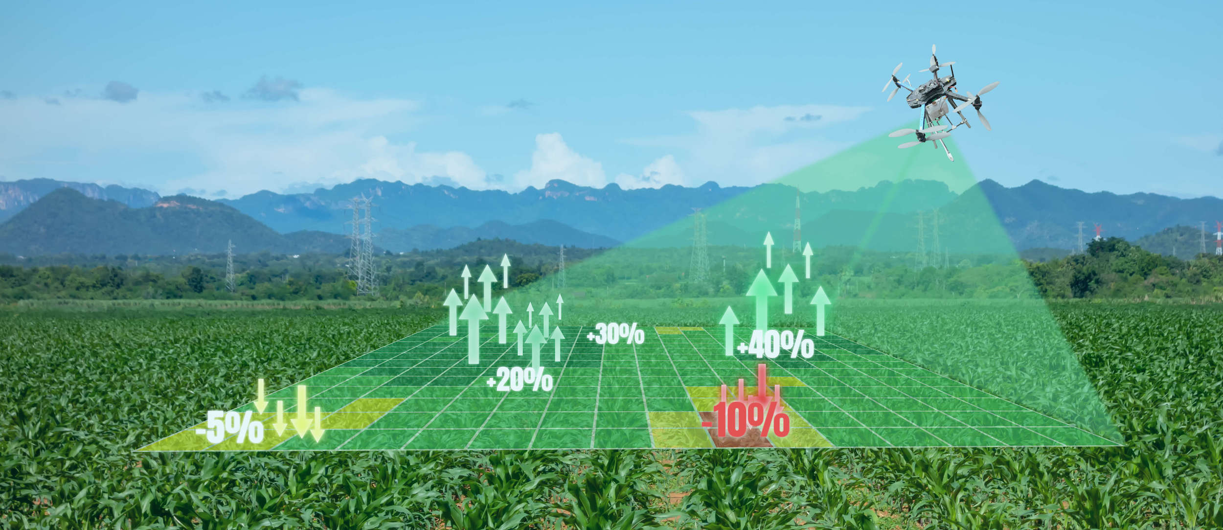
Real-Time Imagery
Satellite imagery can provide valuable information about crops and soil. However, images can only be captured on the satellite’s schedule, and when there is cloud cover, the data is not useful. To allow more flexibility, many farmers use drones to capture images on their own schedule, including when there is cloud cover. Repeatable flight plans and workflows capture consistent data, and drones are more accurate, affordable, reliable, and flexible than satellites.
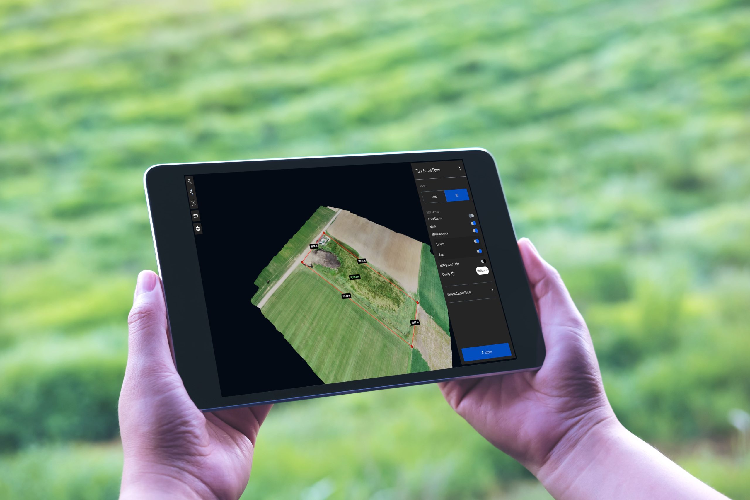
Photogrammetry
Photogrammetry software allows farmers to create 2D photomosaic maps and 3D models from the imagery captured by drones. When compared, the maps show changes over time to monitor crop health. High resolution enables farmers to zoom into small areas—in some cases, down to the centimeter—to identify pests.
Remote Sensing
Multispectral sensors on drones and satellites can be used to show moisture levels in soil, temperature differentials in a field, and other metrics that help assess crop health.
Field Sensing
Sensors in the field can accurately measure moisture levels in soil, air temperature, and so on to provide constant, real-time measurements. These sensors can be programmed to provide alerts when certain conditions are met so farmers can act quickly as needed.
Data Integration
Information gathered from real-time imagery can be integrated with other software, maps, and data to paint the most complete picture and enable informed decisions.
Benefits of Precision Agriculture
Precision agriculture offers many benefits for farmers and agricultural agencies.
Higher Yields
By taking steps to improve soil health and use the right fertilizers at the right time, farmers are able to increase crop yields, reduce expenses, and grow profits.
Less Waste
With precision agriculture, farmers can use the minimum amount of fertilizer and apply it only in the areas that need it, creating less waste and reducing unnecessary expenses. They can also intervene when crops are diseased to prevent spreading diseases to other crops.
Environmental Protection
Precision irrigation is the practice of using only the necessary amount of water and only when it’s needed. This helps reduce water pollution from runoff. It also allows farmers to use less water, fuel, and fertilizer, reducing their environmental impact.
Use Mapware for Precision Agriculture
Mapware photogrammetry software allows you to quickly create and analyze 2D maps and 3D models to make informed agricultural decisions. Whether you save a crop with early detection and removal of diseased plants or use sensors to assess soil moisture, using drones with Mapware for precision agriculture can help you reduce costs, increase profits, and shrink your environmental footprint.
Ready to put Mapware to work for you? Start a free trial today!


