photogrammetry drone view of field road and water

A Complete Guide to Remote Sensing Technology

Remote sensing technologies have transformed the way we see our world. Here’s what you need to know about this exciting data collection method.

What is remote sensing?

Remote sensing is an advanced surveying and data analysis methodology that uses airborne sensors to document important environmental or structural information faster and more accurately than ever before.
When paired with machine learning and mapping software, remote sensing can convert raw image data into measurable 3D maps and provide insight into changing conditions over vast temporal and spatial distances.
For researchers and engineers in the field, remote sensing is a valuable toolset that reduces manual work and enables data collection in difficult and dangerous environments.

What is the difference between remote sensing and GIS?

Remote sensing and GIS are two parts of the same data collection and analysis ecosystem.
Remote sensing encompasses all the tools used in aerial surveying, while GIS is a suite of hardware and software that processes large amounts of data from remote sensing sources (for example, Google Earth).
In practice, remote sensing data is only as good as the GIS software processor you use, and vice versa.

A Brief History of Remote Sensing

Like a lot of emerging technologies, remote sensing has its roots in the early days of the space age. Between 1954 and the mid-70s, dozens of remote sensing prototypes were launched into space to collect data from all over the electromagnetic spectrum.
These satellites were used to track weather patterns, photograph enemy bases from high above the stratosphere, and provide researchers with incredible new views of the planet we call home.

Remote sensing technology timeline

French artist Louis Daguerre -1839

1839

French artist Louis Daguerre invents the first practical-use camera, the daguerreotype, using a silver-plated sheet of copper treated with iodine vapor.
The Wright Brothers - 1903

1903

The Wright Brothers take off at Kitty Hawk, North Carolina, flying a total of 852 feet in 59 seconds, and thereby achieving the first powered, sustained, and controlled manned flight.
Biplane illustration - 1916

1916

WWI pilots strap camera technology onto biplanes to document conditions behind enemy lines. This early form of aerial photography sets the stage for a century of airborne surveillance.
Illustration of Sputnik - 1957

1957

Sputnik, the first manmade object in space, is launched into orbit by Soviet military scientists.
NASA Scientists around first weather satellite, TRIOS-2 - 1960

1960

NASA launches the first weather satellite, TRIOS-2, into orbit, where it performs remote sensing of environment conditions on Earth for 78 days.
Image of Telestar - 1962

1962

Telestar, a medium orbit satellite designed to enable high speed telephone calls, is launched into space, inaugurating a new era of satellite-enabled telecommunications.
Black and white image of orbital remote sensing satellite - 1964

1964

By this point, sensors are used in orbital remote sensing to document virtually all of the electromagnetic spectrum.
Image of one of the SMS-1 or SMS-2 weather satellites in orbit NASA - 1975

1975

NASA launches two weather satellites, SMS-1 and SMS-2, that demonstrate the feasibility of using satellites in geosynchronous orbit for meteorology.
Illustration of Orbital Remote Sensing technology - Early 1980s

Early 1980s

Orbital remote sensing technology is used to track and document rising global temperatures related to CO2 pollution.
Image of Hubble space telescope in orbit - 1990

1990

NASA launches the Hubble space telescope to perform wide-reaching remote sensing and analysis.
Drone pilot holding unmanned UAV - Early 2010s

Early 2010s

Advances in unmanned UAV technology make shooting photos and video from drones a possibility, leading to an explosion of both hobbyist and commercial drone pilots.
White, remote-sensing drone in field

Today

Today, remote sensing is more than just one tool or method — it’s a broad-reaching, interdisciplinary practice that provides decision makers with actionable, real-time information.

Some recent use cases include:

How Remote Sensing Works

Remote sensing is used to collect massive amounts of data on landscapes, infrastructure, and more. But how does it work?

The electromagnetic spectrum and remote sensing

Energy travels in waves, whether it’s kinetic force acting on a solid object or visible light emitting from the sun.
All matter reflects, absorbs, or transfers energy in a unique manner. Advanced sensors can determine a lot about an unknown object by studying its interactions with energy sources.
With the right sensors in place, simple variations in visible light can lend clues about the objects below — for example, the health and growth potential of vegetation photographed from a thousand meters in the sky.
Illustration of light on visible spectrum with wavelengths and colors
The wavelengths reflected off rocks, vegetation, soil, and manufactured objects are unique from a spectral standpoint. Each can be used to create a fingerprint that identifies an object’s type of matter, its density and chemical composition, and more.
Researchers use high-powered sensors that are uniquely tuned to capture evidence from a number of spectral bands for further analysis. That data could be used to measure a number of things about the terrain below, like the predominant mineral on a hillside, the density and composition of foliage, or the size of a mound of construction refuse.
Light on the visible spectrum is the most commonly studied metric in remote sensing, though ultraviolet radiation and infrared light are valuable for specialty purposes. While some sensors are equipped to document infrared light, most visual documentation systems use aerial photography and photogrammetry to accumulate data.

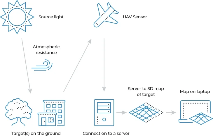
How photogrammetric remote sensing works

Flowchart of how photogrammetric remote sensing works
Remote sensing uses airborne sensors to collect wavelength data from objects on the ground in the form of images, infrared readings, and more.
In one popular method, photogrammetry, source light from the sun bounces off the target, which is collected by sensors on a UAV, manned aircraft, or satellite.
That data is pinned using GPS positioning, and sent to a server for collection and normalization for atmospheric factors, such as humidity, time, date, and more.
From there, that data can be processed using GIS technology to create a measurable 3D survey map. Differences in data over time or variances in color, chemical composition, temperature, or other factors can provide on-the-ground insight from high above.

What is spatial resolution in remote sensing?

Spatial resolution defines the amount of on-the-ground visual data collected in each image pixel. This metric is usually determined by measuring the physical size of a pixel represented in meters, so 100m resolution involves a pixel that documents 100 meters by 100 meters on the ground.
In remote sensing, resolution is a measure of the electromagnetic wave that includes radiometric and temporal components as well. Other common metrics used in remote sensing are:
  • Spectral resolution, which describes the capacity of a sensor to document color, infrared light, or other electromagnetic wavelengths.
  • Temporal resolution, which describes the time elapsed between images or data sets.
High-resolution remote sensing will produce visually, spectrally, and spatially rich data sets, complete with robust metadata. In order to ensure the accuracy and quality of your data set, be sure to check the metadata for information on how your data was produced, when, and by whom.

Need help understanding distortion with aerial photography?

Read our blog post on errors in remote sensing.

What is metadata?

Broadly speaking, metadata is data about data. It’s also an indispensable piece of the remote sensing data processing ecosystem.
Metadata in photogrammetry could include notes related to:
  • GPS coordinates
  • Time/date
  • Focal length
  • Resolution settings
  • Atmospheric conditions
  • And more
Metadata offers valuable insight into the conditions a data set was created under, who created the data and, in many cases, the overall value it creates for a project.
It also serves as a signpost for organizing automated object identification, which is essential for surveying and three-dimensional map creation.

Photogrammetry vs. LiDAR

Photogrammetry and LiDAR are two popular technologies used in remote sensing. Each is used to accomplish specific ends, and each comes with its own strengths and limitations.
UAV image of tower demonstrating Photogrammetry vs. LiDAR

What is photogrammetry?

Photogrammetry uses ultra high resolution aerial images to produce actionable data for GIS mapping systems.
When mounted on airplanes, helicopters, or UAV drones, photogrammetric technology produces dynamic surveying data that can be transformed into a fully-measurable 3D plat map with photo-quality imagery.
These composite landscapes can be used to power environmental research, perform surveillance, and feed predictive analytics systems.
LiDAR topographic map of river and forest

What is LiDAR?

LiDAR uses laser-targeted distance measurement to create a detailed point-by-point map of an object’s position in space.
Inspired by sonar and echolocation, this technology is highly versatile and has been used to power everything from automated driving software to augmented reality to advanced surveying.
This remote sensing method is commonly used to examine large land parcels for structure, density, and vegetation.

Popular Use Cases for LiDAR and Photogrammetry

Table comparing popular use cases for LiDAR and Photogrammetry

What sets LiDAR and photogrammetry apart?

LiDAR and photogrammetry are highly accurate methods for surveying buildings, infrastructure, and large swaths of land. What makes each unique?
 Photogrammetry illustration

Photogrammetry

Photogrammetry uses positional measurements on objects in aerial photographs to produce surveyor-quality distance assessments.

This method is affordable, and cameras are easy to mount on low-cost UAV technology, which is ideal for generating a lot of data or performing surveillance on a budget.

 LiDAR illustration

LiDAR

LiDAR collects more detailed measurements than photography, in part because it uses physical measurement techniques to map distances. 

It’s also considerably more expensive to set up and calibrate and lacks a photographic element on its own that is vital for many studies.

Both LiDAR and photography systems for photogrammetry can be mounted on small aircraft or unmanned UAV drones, making them especially useful in situations where climate, remoteness, or the magnitude of a project make manual surveying and documentation resource prohibitive.

Learn more about LiDAR vs photogrammetry

Practical Applications of Remote Sensing

A full overview of remote sensing in various fields:
Oil & Gas

Oil & Gas

Aerial photography has been used for some time in the oil and gas industries, mostly to survey large areas for pipeline construction and inspection.
In recent years, remote sensing and AI have combined to streamline essential monitoring by automatically identifying damage and leaks to minimize impact and accelerate remediation.
Agriculture

Agriculture

Remote sensing allows farmers to assess biomass of their crops by estimating volume and identifying key factors like erosion, drought stress, pests, and disease that impact overall yields. This data can be used to create detailed production forecasting.
Farmers can also use agricultural monitoring remote sensing to track changes in ecosystems, provide verification for crop insurance, and support research efforts.
Utilities

Utilities

Water and energy projects are undertakings of massive scale that are usually situated in remote settings. Surveying property, monitoring equipment for fire risk, and performing surveillance on vital infrastructure are all full-time tasks.
UAV remote sensing can be used to track erosion and vegetation growth around infrastructure, track damage and land changes, prevent theft, and more.
Telecom

Telecom

Electrical and telecom maintenance is one of the most dangerous jobs in the U.S.
UAV photogrammetry can inspect cell towers and power lines without putting workers in harm’s way. With remote sensing data, workers can prepare for maintenance tasks with detailed repair plans to minimize unnecessary climbs.
Construction

Construction

Photo documentation is a budding industry driven by the need for construction accountability.
UAV imagery processed using photogrammetry is a valuable tool for accurately measuring distance, elevation, and volume on site, especially for earthworks projects that are notoriously difficult to track and document.
Public safety

Public safety

Disaster response and documentation of land changes, pest infestations, and invasive plant growth are emerging uses for remote sensing technology.
UAV technology can also aid in public safety by tracking invasive weeds around potential ignition sources to monitor wildfire risk, providing first responders with a view of on-the-ground conditions after a tornado or hurricane, and more.

Learn more about using photogrammetry for environmental monitoring.

The Future of Remote Sensing

Remote sensing technology has long been on the cutting edge of engineering and research. Now, it’s evolving to make data-tested predictions on a local scale, create business results, and empower decision makers with insight into natural cycles and human behaviors.
Artificial intelligence is already used regularly in remote sensing data analysis to pinpoint objects as reference points for identification and measurement. AI allows researchers to turn raw data and images into interactive 3D maps, environmental analyses, and surveys without spending hundreds of worker hours doing so.

Predictive analysis in action

Predictive analysis is the next frontier for remote sensing. This technology uses machine learning to build data-based scenarios from remote sensing image processing data. These real-world outcomes are tested in hundreds or thousands of iterations by AI automation to establish accurate, reliable patterns. The results can be used in numerous use cases, including:
  • Disaster risk reduction
  • Asset selection and protection
  • Event prediction for timely response and recovery
  • Economic decision making
  • And more
While this kind of predictive capability has existed for institutional players for a few years now, the expansion of UAV technology and advanced GIS mapping make it possible for local governments, smaller companies, and other organizations to access valuable insights like these for themselves.
Already, local studies on flood plains are being deployed by first responders and community leaders in Senegal to mitigate the impact of seasonal weather cycles.

Gaze into the crystal ball with us.

Read more about remote sensing in disaster management in our predictive analysis blog post.

Learn More About Mapware

When it comes time to use advanced mapping techniques in the field, you want a partner with the right experience for the job. Mapware has the expertise to create value for you and your customers by deploying the right remote sensing solution for the job.
The new Mapware photogrammetry software is best-in-breed, AI-powered GIS software designed to process remote sensing data sets with more precision than ever before.
No matter whether you want to map a single building project, a half dozen cell towers, or a whole pipeline system, this software is designed to create bigger, more interactive 3D maps that are fully cloud accessible. That means the freedom of remote access from anywhere with an internet connection.

Mapware is an indispensable asset for researchers, engineers, and project managers in a number of industries. What can we do for you?

Learn how remote sensing technology can provide a leg up in your industry.