The Aerial Perspective Blog
Introducing Mapware Fly

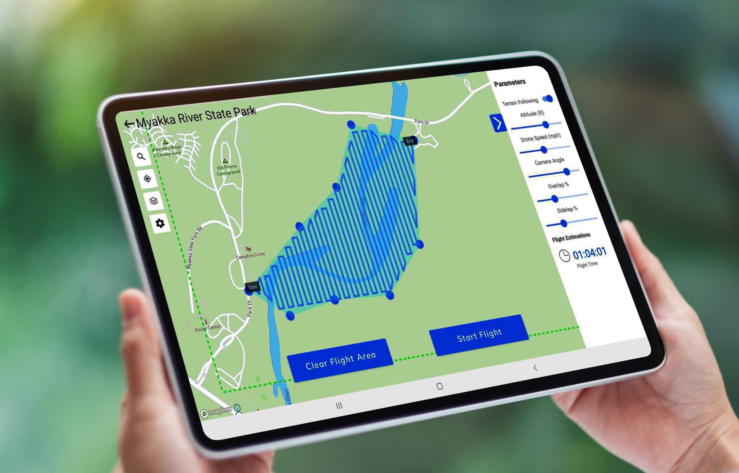
With Mapware’s new drone mapping software, you can automate image capture flights with one of four compatible DJI drones and sync them with our photogrammetry engine.
Introduction
In case you haven’t noticed from our recent blog post and our activity on social media these past few months, we’ve been thinking a lot about drone mapping software. We realize it’s hard to capture high-quality photos under manual flight control. And we also realize that the best photogrammetry software is incomplete without addressing the photo flight.
That’s why we’re proud to announce Mapware Fly — a free new Android app for drone flight planning, flight control, and image capture that seamlessly integrates with our cloud-based photogrammetry software.
This will probably come as no surprise if you’re active on UAV mapping forums on Reddit or Facebook. You may even have been one of our public beta testers. If so, thank you. The information you helped us gather has resulted in an app that is comprehensive enough to elevate the quality of your digital twins, but streamlined and accessible enough for use by novice pilots.
Technical specifications
Where to find it:
- Where to find it: on the Google Play Store
- Supported devices: Android tablets running Android 11 and newer *
- Compatible drones: DJI Mavic 2 Pro, DJI Phantom 4 Pro V2.0, DJI Mavic Air 2 and DJI Mini 2 drones *
* Support for additional devices and drones is coming soon.
Overview of features
Here are a list of the main features and benefits of our app.
Direct Upload to Mapware
As missions are completed, users can sync the captured images with their Mapware account to turn captured images into accurate, detailed 3D maps and orthomosaics.
Terrain Following
Mapware Fly users can set a target altitude for their autonomous flight. When terrain following is turned on, the drone’s height above ground level will automatically adjust as the underlying terrain changes.
Automatic Flight Paths
Users simply draw an outline of their “area of interest” on an interactive map, and Mapware Fly will automatically create the optimal flight path based on their configured flight parameters.
Live Video Preview
Users can see a picture-in-picture drone’s-eye-view to confirm that the drone is working correctly, and the mission is going as planned.
Live Telemetry
During flights, users can view realtime drone telemetry information including Above Ground Level (AGL) altitude, Mean Sea Level (MSL) altitude, horizontal and vertical speed, SD card space remaining, drone battery, and distance to home (takeoff location).
Preflight Checklist
Mapware Fly helps users perform successful missions with a preflight checklist at the start of each flight. The app confirms that the drone is properly connected, has enough battery life to perform the mission, and that the flight path doesn’t encroach on restricted airspace.
Offline Operation
Users can plan and execute drone missions at a remote site without needing a Wi-Fi or cellular signal.
View Restricted Airspace
While planning a flight, Mapware Fly automatically highlights “restricted” and “authorization” airspace zones on the mission map. With this feature, users can feel confident that their drone flights are compliant with local restrictions.
Project Organization
Missions can be organized into projects, which is helpful for managing multi-mission projects, organizing missions by customers, and more.
Create Missions Without a Connected Drone
Users can create and plan a mission without connecting their device to a drone. This feature allows users to plan missions before they go out into the field, so they don’t waste valuable field time.
Cloud-Based Projects
Project and mission data is synced to users’ Mapware accounts. This synchronization allows the user to create a complete or partial mission on one device, log out, and then log in on another device to continue mission planning and execution.
Video Demo
Here’s a quick video tour of a Mapware Fly mission from start to finish.
Mapware makes flight planning and capture easy. Download Mapware Fly and see for yourself.
Join our mailing list to stay up to date on the latest releases, product features and industry trends.
Mapware needs the contact information you provide to us to contact you about our products and services. You may unsubscribe from these communications at any time. For information on how to unsubscribe, as well as our privacy practices and commitment to protecting your privacy, please review our Privacy Policy.


