BALLOON POD
A persistent ISR system designed for long duration overwatch and tactical observation.
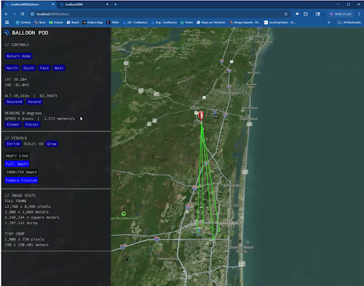
The Balloon POD is a persistent Intelligence, Surveillance, and Reconnaissance (ISR) system featuring a specialized stratospheric balloon platform design. Its pressure-stabilized vessel, integrated with advanced highly accurate camera technology, delivers best in class geolocation accuracy and operational stability. From loitering in the extreme stratosphere to providing persistent overwatch for tactical observation, it mirrors the heavens’ silent vigilance and unwavering clarity.
The New Frontier of Persistent Stratospheric Intelligence
Mapware’s mission-validated deployments of the Balloon POD have established its dominance in the tactical stratosphere, providing the premier solution for persistent overwatch, DoD reconnaissance, and wide-area intelligence capture. By leveraging Phase One’s high-resolution sensors and Trimble’s position systems, it offers a cost-effective, high-fidelity alternative to traditional satellite platforms
Why Balloon POD?
Mapware technology reinvents stratospheric surveillance by moving away from fixed-sensor payloads and high-cost satellite alternatives. Through an adaptable multi-sensor housing, you no longer require custom-built vessels to achieve the high-altitude intelligence your mission demands.
This pressure-stabilized architecture allows for seamless sensor swaps as technology evolves, keeping your persistent ISR operations at the technological forefront without the expense of purchasing entirely new systems. By integrating advanced Phase One technology, this system delivers the high-resolution “soda straw” monitoring required for tactical threat detection and broad-area situational awareness.

Industry Applications
- Persistent Surveillance & ISR
- Provide continuous, long-duration overwatch for tactical observation, border patrol, and DoD reconnaissance mission.
- Leverage high-resolution spot light focused monitoring to observe active threats while maintaining broad-area situational awareness.
- Natural Disaster & Wildfire Tracking
- Enable persistent Earth observation for tracking impacted disaster areas, wildlife habitats, and real-time wildfire evolution.
- Utilize live video feeds and high-frequency data updates to provide immediate situational awareness for emergency management teams.
- Precision Agriculture
- Monitor crop health with multi-spectral or thermal sensors for improved yield management.
- Identify irrigation issues or pest infestations quickly and accurately.
- Communications Relay & Data Backhaul
- Act as a high-altitude node to provide broadband links and secure communications in remote or disaster-stricken areas.
- Integrate Starlink connectivity and encrypted VPN backhauls to extend the operational range for ground forces and remote assets.
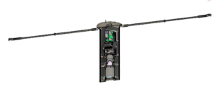
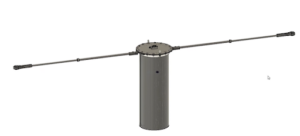
Pressurized container
Sustained hover
Long endurance
Balloon POD’s Specifications and Key Features
Specs | Weight: 33.05 lbs. Height: 24.2 inches. Diameter: 10.75 inches. Width with antennas Deployed: 7.25 feet. |
Camera System | Phase One P5 or iXM-GS120 high-resolution imaging platform with a 300 mm RSM lens specifically designed for high-altitude mapping. |
Positioning System | Trimble Applanix AP+18 GNSS-inertial system. |
Antenna | Calian Full GNSS L-Band antenna. |
Storage Capacity | 4TB or 8TB |
Altitude Capability | Designed to operate in the stratosphere, maintaining internal pressure and temperature at altitudes up to 85,000 feet. |
Connectivity | Features Starlink connectivity for high-bandwidth data transmission and a secure VPN backhaul. |