The Aerial Perspective Blog
What is Terrain Following?
Terrain following is an important feature for drone flight planning software, but not all apps on the market support it. Pilots should understand how it works to maintain regulatory compliance and capture high-quality image sets.
Introduction
Flight planning, automation, and image capture apps are essential tools for professional drone mappers. They save time and battery life, reduce pilot workloads, and enhance image quality. But many options on the market are designed to automate flights over flat terrain. To map areas with changing elevations, you need more granular altitude control than that provided by most waypoint flight plans. This is why some flight app designers have added an advanced feature called terrain following.
This article describes the purpose, benefits, and limitations of terrain following so you can decide if it’s worth having.
The problem with lawnmower flight patterns
Most flight apps create what are sometimes called “lawnmower” flight patterns. The name comes from the way they sweep a drone back and forth over the landscape at a fixed altitude. Lawnmower patterns ensure full horizontal coverage of the site but make few (or perhaps no) changes to the drone’s altitude. Instead, these apps let the pilot set a fixed mission altitude beforehand. When the mission starts, the drone climbs to that altitude and stays there until the mission is complete.
Fixed altitude is fine if you are mapping a parking lot in Florida. With no significant elevation changes, your drone camera stays roughly the same distance from the ground when it snaps each photograph. But what if you are mapping a hiking trail in West Virginia? The terrain will rise toward the drone and fall away from the drone, perhaps drastically. This causes the drone’s real-world height above the ground to fluctuate, negatively impacting your mission in several ways.
In the extreme case, your drone might risk crashing into the terrain or breaching FAA altitude limits. More likely, though, changing elevations can introduce subtle variations in your image set that result in a poor-quality 3D model. More on this later.

The purpose of terrain following
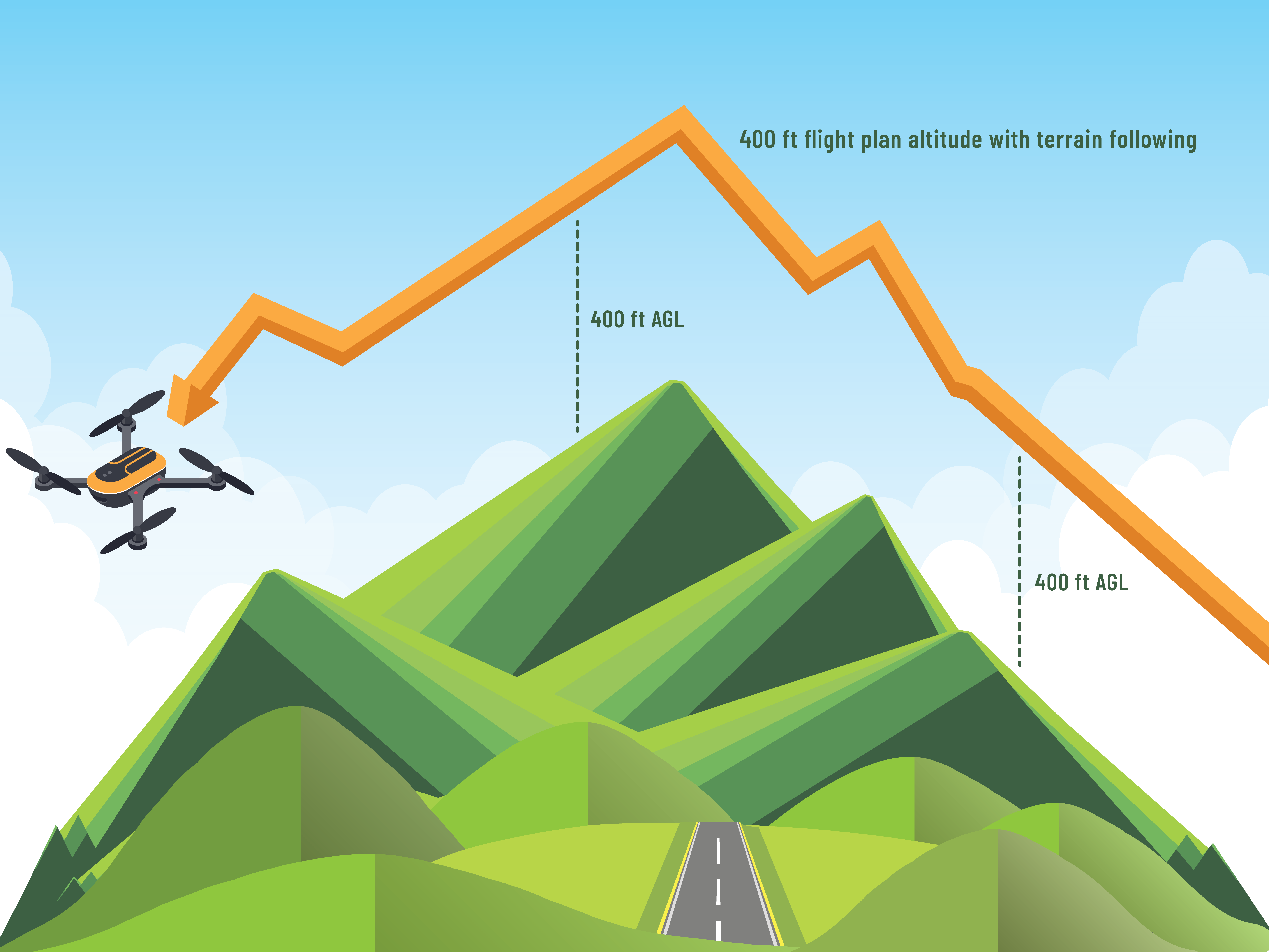
With terrain following, a flight app makes real-time adjustments to your drone’s altitude to mirror the contours of the terrain. Instead of flying straight, the drone climbs and descends in real-time to maintain its ideal height above the ground throughout the mission. In aviation terms, terrain following helps your drone maintain a consistent altitude above ground level (AGL).

How does it work?
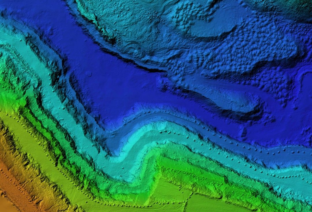
Flight planning apps achieve terrain following by reading geospatial data sources to know the elevation of the ground directly underneath the drone. As the drone flies along its automated flight path, the software looks up the elevation at its current GPS location and adjusts the drone’s altitude to match any recent changes.
NOTE: Because all this happens in the drone’s flight computer, you can point your camera at any angle to the ground and it won’t affect the accuracy of terrain following.
What are its benefits?
Now that you understand what terrain following does in general, we’ll discuss some specific benefits it has for your mission.
Maintaining Part 107 compliance
The main reason for terrain following is to protect pilots from breaking FAA regulations. According to 14 CFR Part 107.51(b), small commercial drones must not exceed 400 ft AGL during any portion of their flight. That’s easier said than done.
Let’s say you’re tasked with mapping a region of forest that slopes down the side of a mountain. You might want to set your flight app’s altitude at or near 400 ft AGL to ensure clearance with trees or other obstacles, or to cover a wider area per photo.
Automating this mission without terrain following would be nearly impossible. As soon as your drone flew over a downward slope, its initial 400 ft would become 401 ft and instantly exceed the FAA’s maximum. Then again, if your drone flew up the slope, an initial 400 ft might become 300 ft… and 200 ft… and 100 ft… Eventually, the drone would risk crashing into the treetops.
But with terrain following enabled, you could start your mission anywhere along the slope. The software would keep your drone at 400 ft AGL throughout the mission.
Improving image quality
Drastic elevation changes can degrade the quality of your drone images in several ways. Here’s how terrain following can prevent that.
Consistent GSD
By keeping the drone at a consistent height from the ground, terrain following ensures your drone will take each image with a consistent ground sample distance (GSD).
GSD is the amount of real-world space captured by each pixel in an image. When your drone camera gets closer to the ground, it captures a smaller geographical area in its field of view. But in general, this is what you want. Since you’ve divided that geographical area into more pixels, you can measure even smaller features with accuracy. This comes in handy when your client wants to accurately measure the length, width, and height of everything in their digital twin down to the centimeter.
Regardless of your client’s specifications, GSD is something you want to control. Terrain following reduces fluctuations in image GSD caused by a straight drone flight over rolling terrain, ensuring you maintain whatever GSD you need.
Consistent overlap
Overlap is an important requirement in drone photogrammetry, ensuring photogrammetry software can identify common features between images to pair them side by side.
For most standard projects, Mapware recommends pilots configure their flight planning software to take images with 70% front and 70% side overlap to ensure high-quality photogrammetry. Anything below 60% may not process.
But if your flight planning software doesn’t have terrain following, your preset overlap will go out the window as soon as the terrain elevation changes. Whenever the terrain rises toward the drone, features in its field-of-view will be pushed off camera, reducing overlap. Whenever the terrain falls away, more features will be visible in each shot, increasing overlap.
For hilly worksites, terrain following is critical to ensure your drone varies its automated flight path and takes photos at the overlap you want.
Consistent scale
Another benefit of terrain following is that it helps the drone take photos at a consistent distance from the ground. Most photogrammetry processing software is robust enough to handle differences in scale between photos in the data set, but even the best algorithms have their limits. Photos of drastically different scale might be discarded during the photogrammetry process, or they might result in distorted or low-quality 3D models.
What are its limitations?
While terrain following is an important feature, it can’t do everything. Take note of the following limitations.
Obstacle avoidance
Do not confuse terrain following with obstacle avoidance. Elevation data rarely if ever accounts for structures sitting on the ground, so terrain following will not keep your drone from crashing into the side of a building.
In a similar way, terrain following will not give your drone the ability to see and avoid other aircraft.
Rapid elevation changes
Even if flight planning software has terrain following, it may not be able to handle particularly rapid changes in elevation. For example, a drone approaching a vertical cliff face may not ascend in time to clear the edge. Instead, it may climb toward a point on top of the cliff but at an angle that intersects with the cliff wall.
Final thoughts
Terrain following is by no means required for successful drone mapping missions, especially if you rely on manual flight control techniques. But if you automate your image capture flights, terrain following is a game changer for mission sites with sloping, uneven ground. As clients request digital twins of increasingly remote locations, you should have terrain following in your mission toolbox just in case.
Join our mailing list to stay up to date on the latest releases, product features and industry trends.
Mapware needs the contact information you provide to us to contact you about our products and services. You may unsubscribe from these communications at any time. For information on how to unsubscribe, as well as our privacy practices and commitment to protecting your privacy, please review our Privacy Policy.


